
The Philippines conducted its own landing shortly after on the reef that is just 5 nautical miles from its military outpost on the nearby Thitu Island.
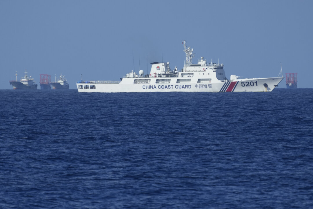
China’s coast guard said on April 27 that the Philippines “violated China’s territorial sovereignty” after Manila dispatched officers to land on sandbars that the Philippines considers part of its sovereign territory.
Six Filipino officers landed on three exposed sandbars of Sandy Cay in the Thitu Reefs on April 27, just a day after Chinese state media CCTV reported that Chinese officers had done the same on one of the sandbars—specifically Sandy Cay 3—of Sandy Cay, which the Chinese call Tiexian Reef.
“This routine inter-agency operation reinforces the Philippines’ commitment to safeguarding its maritime domain, adhering to the international law, and ensuring peace and stability in the region,” Philippines coast guard spokesperson Jay Tarriela said in a statement on the Philippine landing.
China coast guard spokesperson Liu Dejun responded by urging the Philippines to cease its landings “immediately” and that the Chinese coast guard would continue to “carry out law enforcement activities” within the waters it considers part of its jurisdiction.
Earlier on April 26, images of khaki-clad China coast guard officers unfurling the Chinese Communist Party’s (CCP’s) flag to proclaim control over Sandy Cay were broadcast across China by state broadcaster CCTV.
The CCTV report said the Chinese coast guard’s landing at Sandy Cay “implemented maritime control” over Tiexian Reef and had happened in mid-April.
The landing was to “exercise sovereignty and jurisdiction” over the reef, carry out an “inspection” and “collect video evidence” of the activities by the Philippines, the state media report said.
Local Philippine media reported that there didn’t appear to be any attempt by China this time to permanently occupy or build any structures on Sandy Cay.
The Philippines accused China of illegally landing on the tiny sandbank, as the cay lies just five nautical miles from the Philippine-occupied Thitu Island, which was classified as a “rock” in the 2016 Hague Tribunal ruling in the Philippines v. China arbitration on the U.N. Convention on the Law of the Sea (UNCLOS). States are entitled to 12 nautical miles of sovereign territory around “rocks,” which extends to the airspace above and the seabed below, under international maritime law.
The Philippines then proceeded with its April 27 landing.
Manila currently holds de facto sovereignty due to its presence on Thitu Island, which it calls Pag-asa. Like Thitu Island, Sandy Cay is classified as a rock under UNCLOS, as it remains above water at high tide.
The 92 acres of Thitu Island and the five sand bars of Sandy Cay make up the Thitu Reefs. The reefs are among the Spratly Islands that lie beyond the 200-mile exclusive economic zone (EEZ) or continental shelf of any one nation. Brunei, China, Malaysia, the Philippines, Taiwan, and Vietnam all have overlapping claims of sovereignty in the contested region, which has significant oil and natural gas reserves.
Tussle for Control
China observers have long voiced concerns that the CCP was planning a land grab at Sandy Cay.
China has been “watching Sandy Cay” for a long time, Philippines’ ambassador to China, Chito Santa Romana, has warned.
The past decade has seen the two nations locked in an ongoing tussle over the sliver of sand that remains above water because of what it means for territorial claims in the region under UNCLOS, even though China has ignored international law under UNCLOS in many other instances across the South China Sea.
In 2017, a flotilla of Chinese ships had gathered at Sandy Cay, with Lowy Institute security analyst Euan Graham writing at the time: “China’s ongoing maritime activity around Thitu is worrisome. … If the objective of the operation is to occupy Sandy Cay, that would mean a significant escalation in tension in the South China Sea.”
Filipino Congressman Gary Alejano said at the time, “The Chinese may have a sinister plan to occupy sandbars just west of Pag-asa that belong to us.”

Then, in 2019, another swarm of around 275 Chinese fishing ships appeared in the waters around Thitu Island, reportedly blocking Philippine access to Sandy Cay like they did when they wrestled control of Scarborough Shoal in 2012.
In response, the Philippines declared that the Chinese vessels were in violation of its “sovereignty, sovereign rights, and jurisdiction.”
At the time, the Philippines was repairing a runway and finishing a beach ramp on Thitu Island, which the Chinese may have seen as a feature for U.S. military access to challenge its military presence on the China-occupied Subi Reef, just 10 nautical miles away from Sandy Cay.

As a low-tide elevation, Subi is not a rock and therefore generates no territorial sea of its own.
If the Chinese wrestle control of Sandy Cay from the Philippines, the rock could help China lay a 12 nautical mile territorial claim that would include Subi Reef—although such a claim would still overlap with the Hague’s ruling that Subi is within the Philippines EEZ and continental shelf.
The Philippines says China’s artificial island building at Subi is illegal under UNCLOS and in violation of the Philippines’ exclusive rights to exploit the resources in its EEZ and continental shelf.
The Philippines, China, and Vietnam all have overlapping claims to Subi.
Militarized Subi Reef
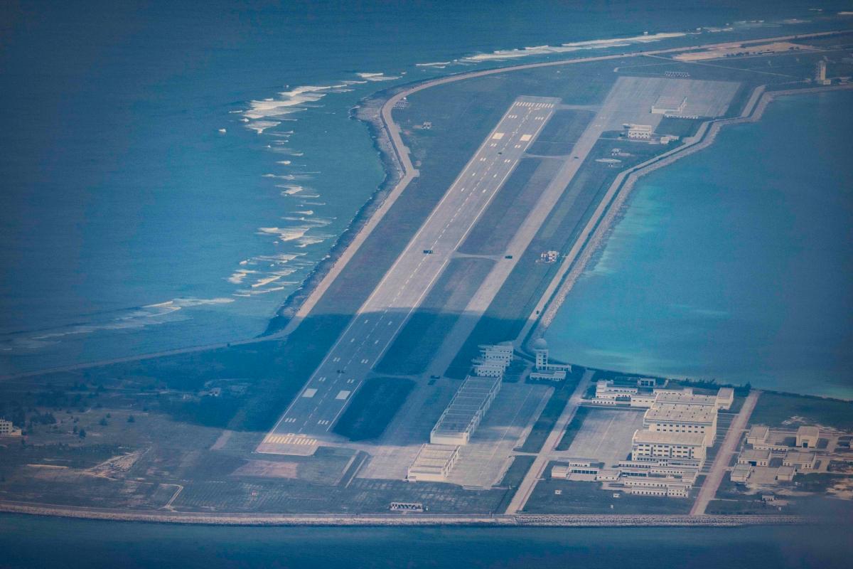
The Chinese have occupied Subi since 1988 and began works to dredge, reclaim, and militarize the reef in 2014. Its artificial reef-building at Subi and other reefs was also criticized by the Hague for causing permanent ecological damage to the nearby coral reefs, in violation of China’s obligations under UNCLOS, specifically Articles 192, 194, and related provisions to protect and preserve the marine environment.
All states with claims to the Spratly Islands, except Taiwan, have ratified the UNCLOS: the Philippines in 1984, Vietnam in 1994, and Brunei, China, and Malaysia in 1996.
Despite this, Beijing maintains that the Hague ruling has no legal basis and continues to assert many of its contested historical claims in the South China Sea.
In December 2024, the Philippine navy’s spokesperson warned that Subi Reef was now serving as an anchoring hub for Chinese ships in the South China Sea, or West Philippine Sea.
Military Drills
The CCP’s claims to Sandy Cay coincide with the United States and Manila’s launching their annual joint Balikatan, or “shoulder-to-shoulder,” military drills on April 21, with the exercises said to be in preparation for a “full-scale battle scenario.” This drew criticism from Beijing, which called them “destabilizing” amid what the Philippines and other U.S. allies consider aggressive actions by the CCP.
“It’s joint training with the U.S. forces to increase our capability in securing our territory and, of course, it will increase our capabilities and our preparedness and responsiveness to any eventuality,” Philippine army Maj. Gen. Francisco Lorenzo said of the drills.
“All of us want to resolve any regional conflict peacefully but should deterrence fail, we need to be prepared,” U.S. Marine Corps Lt. Gen. James Glynn said.
The drills last through May 9.
In early April, China and Cambodia held their own joint military drills at the newly expanded Ream Naval Base on the coast of the Gulf of Thailand.
Reuters and The Associated Press contributed to this report.